InSAR-derived Active-Layer Thickness Distributions
InSAR-derived Active-Layer Thickness Distributions

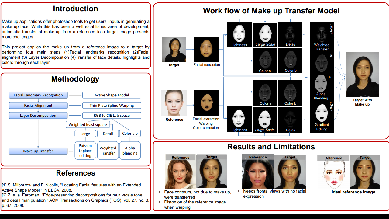
Background:
Large-scale thawing of arctic permafrost has a poorly-understood feedback effect on global climate through the release of CO2 and methane. Active Layer Thickness (ALT) is the maximum annual depth of thaw of surface soils and is designated by the World Meteorological Organization (WMO) as an essential climate variable for monitoring the status of permafrost.Interferometric Synthetic Aperture Radar (InSAR) is a widely-used geophysical technique for measuring surface deformation
at high spatial resolution (Rosen et al. 2000). In recent years, InSAR has been successfully used to measure ground deformation due to seasonal permafrost freeze/thaw cycles and invert this deformation signature for a spatially extensive and finely-sampled map of ALT (Liu et al. 2012; Schaefer et al. 2015).
Proposal:
The ALT retrieval algorithm developed by Liu et al. 2012 generates continuous spatial solutions of ALT within an individual InSAR scene, but algorithm and InSAR processing-related uncertainties can vary considerably across an InSAR scene. Notably, uncertainties in ALT estimation are
higher along scene edges, which can complicate attempts at mosaicking scenes. I will explore different methods of efficiently mosaicking together scenes of ALT. I will explore a mosaicking algorithm that uses feature-matching for image co-registration (as in Tahoun et al. 2014). To reduce image stitching seams, I will implement an adaptive median filter along scene edges which incorporates InSAR phase variance and ALT measurement uncertainties into its weighting element (Toh et al. 2010). I will also explore implementing this median filtering algorithm on phase interferograms before running the ALT retrieval to see if it reduces uncertainties in ALT estimation. Additionally, I will develop a masking algorithm that masks out regions with unacceptable uncertainties via a binarization routine that depends on phase variance and average pixel coherence across InSAR scenes. By applying these image processing techniques, existing ALT retrieval technique can be readily generalized for the generation of seamless regional ALT distribution maps. Logistics: I currently posses the necessary processing scripts and knowledge to generate InSAR scenes and ALT distribution maps from my own research. I will not use an android device.
References:
Rosen P. A. et al. 2000 Proc. IEEE, vol. 88, no. 3.; Schaefer, K. et al. 2015 Remote Sens. vol. 7, 2015.; Liu, L.et al.
2012 J. Geophys. Res vol. 117. Tahoun et al. 2014 IEEE Intelligent Systems 2014 conference. Toh et al. 2010 IEEE
FOR BASE PAPER MAIL US
DOWNLOAD SOURCE CODE CLICK HERE


Comments
Post a Comment